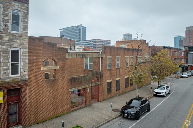
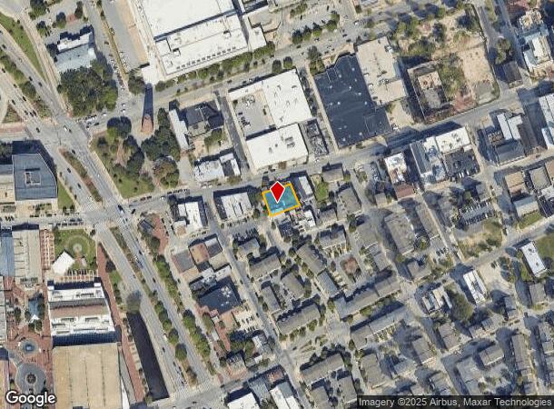
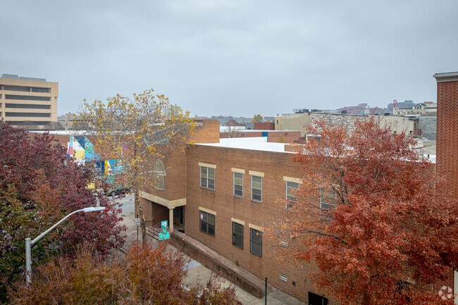
Property Record
1 S High St, Baltimore, MD 21202
Current Lease Availabilities
NEARBY LISTINGS FOR SALE OR LEASE
Property Detail
1 S High St
1360-014
0.191 ACRES
Daycare
Baltimore City
X
Maryland
2400870018G
14
2023
0.20 AC
2025
CBD Baltimore
030200
Baltimore
9,174 SF
Baltimore-Columbia-Towson, MD
DEMOGRAPHICS near 1 S High St
1 Mile
3 Mile
5 Mile
2024 Total Population
41,883
257,873
508,617
2029 Population
40,363
252,811
494,073
Pop Growth 2024-2029
(3.63%)
(1.96%)
(2.86%)
Average Age
37
38
38
2024 Total Households
23,610
117,782
215,789
HH Growth 2024-2029
(3.89%)
(2.41%)
(3.15%)
Median Household Inc
$65,857
$54,460
$54,754
Avg Household Size
1.70
2.10
2.20
2024 Avg HH Vehicles
1.00
1.00
1.00
Median Home Value
$318,432
$223,649
$188,842
Median Year Built
1963
1948
1949
Nearby Places
- Restaurants
- Banks
- Shops
- Fitness
- Groceries
PUBLIC TRANSPORTATION
TRANSIT/SUBWAY
Shot Tower/Market Place (Metro Subway - Maryland Transit Administration Metro Subway (Baltimore Metro))
DRIVE
WALK
Distance
Shot Tower/Market Place (Metro Subway - Maryland Transit Administration Metro Subway (Baltimore Metro))
1 min
2 min
0.1 mi
Charles Center (Metro) Sb (METRO SUBWAYLINK - Maryland Transit Administration)
DRIVE
WALK
Distance
Charles Center (Metro) Sb (METRO SUBWAYLINK - Maryland Transit Administration)
2 min
9 min
0.5 mi
Charles Center (Metro Subway - Maryland Transit Administration Metro Subway (Baltimore Metro))
DRIVE
WALK
Distance
Charles Center (Metro Subway - Maryland Transit Administration Metro Subway (Baltimore Metro))
2 min
11 min
0.6 mi
University Center/Baltimore Street (Hunt Valley & BWI Marshall - Maryland Transit Administration Light Rail (Baltimore Light Rail), Penn Station & Camden Yards - Maryland Transit Administration Light Rail (Baltimore Light Rail), Timonium & Cromwell - Maryland Transit Administration Light Rail (Baltimore Light Rail))
DRIVE
WALK
Distance
University Center/Baltimore Street (Hunt Valley & BWI Marshall - Maryland Transit Administration Light Rail (Baltimore Light Rail), Penn Station & Camden Yards - Maryland Transit Administration Light Rail (Baltimore Light Rail), Timonium & Cromwell - Maryland Transit Administration Light Rail (Baltimore Light Rail))
3 min
17 min
0.9 mi
Johns Hopkins Hospital (Metro Subway - Maryland Transit Administration Metro Subway (Baltimore Metro))
DRIVE
WALK
Distance
Johns Hopkins Hospital (Metro Subway - Maryland Transit Administration Metro Subway (Baltimore Metro))
2 min
17 min
0.9 mi
COMMUTER RAIL
Camden Station (CAMDEN - WASHINGTON - Maryland Area Regional Commuter Trains (The MARC), Camden Line - Maryland Area Regional Commuter Trains (The MARC))
DRIVE
WALK
Distance
Camden Station (CAMDEN - WASHINGTON - Maryland Area Regional Commuter Trains (The MARC), Camden Line - Maryland Area Regional Commuter Trains (The MARC))
4 min
1.3 mi
Penn Station (PENN - WASHINGTON - Maryland Area Regional Commuter Trains (The MARC), Penn Line - Maryland Area Regional Commuter Trains (The MARC), Penn Station & Camden Yards - Maryland Area Regional Commuter Trains (The MARC))
DRIVE
WALK
Distance
Penn Station (PENN - WASHINGTON - Maryland Area Regional Commuter Trains (The MARC), Penn Line - Maryland Area Regional Commuter Trains (The MARC), Penn Station & Camden Yards - Maryland Area Regional Commuter Trains (The MARC))
4 min
1.7 mi
AIRPORT
Baltimore/Washington International Thurgood Marshall
DRIVE
WALK
Distance
Baltimore/Washington International Thurgood Marshall
20 min
11.0 mi
Freight Ports
Port of Baltimore
DRIVE
WALK
Distance
Port of Baltimore
10 min
3.2 mi
Nearby Properties
Address
Land Use
TOTAL SIZE
Lot Size
Zoning
Address
Land Use
TOTAL SIZE
Lot Size
Zoning
1,595,200 SF
20.36 AC
H
Address
Land Use
TOTAL SIZE
Lot Size
Zoning
1,871,691 SF
6.77 AC
C-5DC
Address
Land Use
TOTAL SIZE
Lot Size
Zoning
1,632,000 SF
106.32 AC
EC-2
Address
Land Use
TOTAL SIZE
Lot Size
Zoning
712,573 SF
1.32 AC
C-5DC
Address
Land Use
TOTAL SIZE
Lot Size
Zoning
20.26 AC
C-5DC
Address
Land Use
TOTAL SIZE
Lot Size
Zoning
308,887 SF
3.98 AC
C-5DC
Address
Land Use
TOTAL SIZE
Lot Size
Zoning
21.27 AC
C-5DC
Address
Land Use
TOTAL SIZE
Lot Size
Zoning
739,000 SF
2.79 AC
C-5DC
Address
Land Use
TOTAL SIZE
Lot Size
Zoning
608,666 SF
8.42 AC
H
Address
Land Use
TOTAL SIZE
Lot Size
Zoning
3.89 AC
C-5DC
Address
Land Use
TOTAL SIZE
Lot Size
Zoning
830,720 SF
1.90 AC
I-MU
Address
Land Use
TOTAL SIZE
Lot Size
Zoning
400,000 SF
13.98 AC
0B051
Address
Land Use
TOTAL SIZE
Lot Size
Zoning
654,224 SF
14.98 AC
C-5DC
Address
Land Use
TOTAL SIZE
Lot Size
Zoning
833,702 SF
1.74 AC
C-5DC
Address
Land Use
TOTAL SIZE
Lot Size
Zoning
911,487 SF
5.27 AC
C-5DC
Address
Land Use
TOTAL SIZE
Lot Size
Zoning
381,152 SF
3.46 AC
C-5DC
Address
Land Use
TOTAL SIZE
Lot Size
Zoning
2.61 AC
C-5DE
Address
Land Use
TOTAL SIZE
Lot Size
Zoning
236,614 SF
1.20 AC
BSC
Address
Land Use
TOTAL SIZE
Lot Size
Zoning
268,543 SF
84.93 AC
H
Address
Land Use
TOTAL SIZE
Lot Size
Zoning
241,576 SF
6.13 AC
H
Address
Land Use
TOTAL SIZE
Lot Size
Zoning
199,435 SF
1.19 AC
BSC
Address
Land Use
TOTAL SIZE
Lot Size
Zoning
289,515 SF
1.10 AC
BSC
Address
Land Use
TOTAL SIZE
Lot Size
Zoning
10,386 SF
15.01 AC
C-5IH
Address
Land Use
TOTAL SIZE
Lot Size
Zoning
334,715 SF
1.77 AC
H
Address
Land Use
TOTAL SIZE
Lot Size
Zoning
656,306 SF
1.10 AC
C-5DC
Address
Land Use
TOTAL SIZE
Lot Size
Zoning
579,351 SF
0.96 AC
C-5DC
Address
Land Use
TOTAL SIZE
Lot Size
Zoning
189,700 SF
0.71 AC
TOD-4
Address
Land Use
TOTAL SIZE
Lot Size
Zoning
538,988 SF
8.40 AC
I-MU
Address
Land Use
TOTAL SIZE
Lot Size
Zoning
642,817 SF
1.91 AC
PC-2
Address
Land Use
TOTAL SIZE
Lot Size
Zoning
831,350 SF
5.56 AC
C-2
The World's #1 Commercial Real Estate Marketplace
Connect with us
© 2025 CoStar Group
The information above has been obtained from sources believed reliable. While we do not doubt its accuracy we have not verified it and make no guarantee, warranty or representation about it. It is your responsibility to independently confirm its accuracy and completeness. Any projections, opinions, assumptions, or estimates used are for example only and do not represent the current or future performance of the property. The value of this transaction to you depends on tax and other factors which should be evaluated by your tax, financial, and legal advisors. You and your advisors should conduct a careful, independent investigation of the property to determine to your satisfaction the suitability of the property for your needs.